1. The position of Cyprus in maritime trade networks
Seamen that sailed in the eastern Mediterranean could not miss Cyprus. It is the only island in the region, 65 km away from Cilicia and 105 km from Syria, its mountains being visible from the surrounding mainland. Thus, it is no coincidence that Cyprus was involved in very early maritime ventures from these coasts, already from the 11th millennium BC.1 Due to the currents and the prevailing western winds, the sea-routes from the Aegean to the Levant and Egypt passed by the island, which was often mentioned in written sources as a characteristic landmark or as a stopover for supplies.2 These geographic features made Cyprus a nodal point on the nautical routes of the eastern Mediterranean. Moreover, the Cypriots turned their land into a destination for ships, and not just a landmark or intermediate stopover, by taking advantage of favorable weather conditions and trading the agricultural products as well as the important metalliferous ores of the island.
During the Archaic and Classical periods (7th-4th centuries BC) in particular, the advantages of the island’s strategic position were considerably enhanced; located “between the Orient and the Occident” it could not have been left unaffected by the pan-Mediterranean expansion of seaborne trade, well attested during these centuries4. Indicative evidence of the investment in maritime activities is provided by fifty-three Archaic clay models, of merchantmen and oared ships, found mostly in the tombs of Amathous.5 They depict various representative types of vessels with influences from the Aegean, Phoenicia and Egypt and constitute one of the largest known groups of the kind. This ‘ceramic fleet’ leaves little doubt about the increased, international maritime activity in Cypriot harbours of the period, which had obviously exposed local shipwrights to ship types from different parts of the Mediterranean.6
Excepting ship construction and iconography, another characteristic of ancient maritime civilisations is the production and circulation of products packed in transport containers, commonly known as amphorae. Given that transport amphorae are the only kind of ancient vessel made exclusively for maritime transportation, it is reasonable to suggest that they were manufactured in centres with direct access to maritime trade networks. This was the case with Archaic Cyprus; a type of transport container appeared at the end of the 8th century BC, with morphological features of the local pottery repertoire, the most characteristic of which being the raised horizontal, ‘basket-like’ handles.7 These amphorae were produced throughout the Cypro-Archaic and Cypro-Classical periods, from the end of the 8th to the 4th century BC. Petrographic analyses suggested the Mesaoria Plain as one possible area of provenance.8 Their contents were mainly olive oil or, in some cases, wine. Outside Cyprus, their distribution was more intense in the eastern Mediterranean (Levant, Egypt), while in the Aegean they occur only sparsely, mostly on Rhodes and Kommos on Crete9, which is their westernmost find spot.
2. Shipwrecks
Shipwrecks are the most direct evidence of seaborne trade in antiquity. The study of the ships’ hull provides interesting insights into developments in shipbuilding and navigation as well as diverse aspects of their material culture and the societies that made them.10 The cargo of the ships can be even more revealing, as it reflects the last trip of the ship, and can provide valuable information about sea-routes, trade networks and commodities as well as the often elaborate mechanisms of their redistribution through cabotage.
Navigation in antiquity was based on experience. It presupposed good knowledge of land- and seascapes, in other words distances, landmarks, winds, currents, navigational hazards, stopovers for supplies, harbours, anchorages and shelters.11 Today printed on nautical maps, this kind of information was stored in empirical conceptual maps in antiquity, namely in the seamen’s memory. Such spatio-temporal memory, however, could not easily exceed a period of a few days of continuous sailing,[12] so the information of those “maps” was richer in areas of frequent and repetitive visits, close to the seamen’s homelands. This could perhaps explain a special feature of the diaspora of shipwrecks that is examined below: those with Cypriot cargo have been found beyond the island, and similarly, wrecks in Cypriot waters are of ships coming from some distance. That said, however, we should keep in mind the dangers of the coastal zone: ancient ships used square sails, which were rather cumbersome, especially when they had to execute difficult manoeuvres under bad weather conditions, regardless of how familiar the crew was with the specific area. As a result, many wreck sites are found close to rocky coasts with dangerous reefs, as for example the shipwrecks at Kekova Adasi in Lycia.
2.1. Shipwrecks with Cypriote cargo
2.1.1. Shipwreck of Kekova Adasi, Lycia
The shipwreck at Kekova Adasi is situated at a depth of 8-24 metres, west of the small island Kekova, off the coast of Lycia, close to the ancient cities Timioussa and Simena. During a survey conducted in 2008, fragments of 90 Cypriote ‘basket-handle’ amphorae dating to the 7th century BC, were found scattered and piled on a reef.[13] The ship also carried amphorae from Corinth and the eastern Aegean. No trace of the ship has survived because it was completely destroyed when it crashed on the reef. Although it is impossible to collect any coherent evidence about the content of these containers, it is interesting to note that all of them have been associated with a trade in olive oil.
The composition of this heterogeneous cargo, with vessels from the Peloponnese, the southeast Aegean and Cyprus, is indicative of local redistribution, not of long-distance ventures.[14] In other words, it is almost certain that the ship which sank at Kekova had not loaded its cargo in Cyprus or Corinth. The Cypriot cargo had probably reached some Lycian or Carian port on another ship and from there the whole, or part of it, was reloaded onto a smaller ship, to be distributed at local markets together with other merchandise. It was with small or medium-sized ships of this size, which did not have to travel long distances without stops, that a considerable part of ancient seaborne trade must have taken place.[15] The Kekova Adasi shipwreck is one of the earliest known from the 1st millennium BC, after two Phoenician shipwrecks of the 8th century BC that were found in deep waters, off the coast of Ashkelon, in modern-day Israel.[16]
Cypriote ‘basket-handle’ amphorae have also been found on two wreck sites with scattered cargoes in Caria, at cape Kepçe, east of Bordum (ancient Halicarnassus) and at Cayacagiz Koyu, near Marmaris (ancient Physkos).[17] Although their extremely fragmentary condition does not allow for any coherent conclusions about the ships or the trade networks involved, these sites add two key points on the distribution map of these containers in the Aegean.
2.1.2 The Ma’agan Mikhael shipwreck
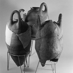
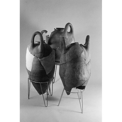
At the end of the 5th century (ca. 400) BC, a small merchantman (about 14 metres long) sank off the Levantine coast, 50 km south of the modern city of Haifa and 70 metres off the coast, near the kibbutz Ma’agan Mikhael.[18] The cargo was seriously disturbed, most probably a result of its location in very shallow waters, about 1.5m deep. Nonetheless, based on the remaining cargo items and the possible Aegean provenance of the ship itself, [19] we can conclude that during its last trip it had called at some Cypriot harbour. In total, seventy pottery vessels were recovered, 60% of which were of Cypriot provenance: ‘basket-handle’ amphorae [Fig. 1], table wares, one pithos, and some lamps, probably deriving from somewhere between Amathous and Kition. The rest of the pottery finds came from the Aegean (20%) and the Levant (10%). Moreover, the ship transferred 12.5 tons of ballast stones, a large percentage of which was grabbro from the river Kouris.
The hull of the ship was preserved in very good condition, a fact that helped to provide valuable information about shipbuilding. It was built with the ‘shell-first’ method, similarly to all Pre-Roman ships we know. However, two different techniques were used to assemble the timbers, also known from other shipwrecks of the Archaic and Classical periods. For the largest part, mortise-and-tenon joints had been used, secured with pegs. Yet at the ship’s extremities, the bow and the stern, some of the timbers were instead sewn together. The sewing technique has been attested in excavated ships dating to the 6th century BC at Marseilles, on Sicily and in the Aegean and is related to the Greek maritime tradition. The fastening technique with mortise-and-tenon was adopted by the Greeks during the Classical period, but as the mixed technique of the Ma’agan Mikhael ship suggests, transition from one technique to the other occurred gradually.[20]
From the analyses of the timber used for building the ship, it is gathered that it must have been constructed somewhere in the southeast Aegean.[21] Moreover, the Cypriote table ware probably comes from the areas between Amathous and Kition. The cargo and the ballast are of key importance for the reconstruction of the ship’s last journey, possibly associated within the regional sphere of interaction in the eastern Mediterranean.[22] As attested in ancient geographic texts, ships that sailed from the Aegean to the Levant, after having reached Cypriot waters at Akamas, continued with a south-southeast direction and changed their course after Akrotiri, sailing southeast;[23] otherwise, they may have continued along the south coast, where a stopover at Amathous or Kition is possible. This may be where the Ma’agan Mikhael ship loaded Cypriot pottery and perhaps olive oil in ‘basket-handle’ amphorae, before it continued its trip to the Levant, where it sank.
2.2. Shipwrecks found in Cyprus
2.2.1 The Mazotos shipwreck
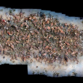
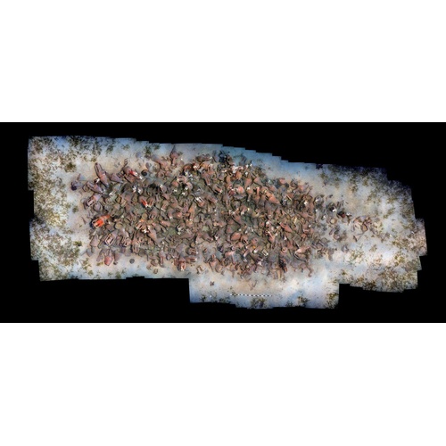
Around the middle of the 4th century BC, a Greek ship sank off the south coast of Cyprus, near the modern village of Mazotos. It was found in very good condition, almost undisturbed, at a depth of 45 metres [Fig. 2].[24] According to estimations thus far, the ship carried around 800 amphorae (at least 20-25 tons). Although its excavation is still in progress, earlier work has provided a good indication of the ship’s length, which is estimated at 18- 20 metres.
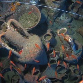
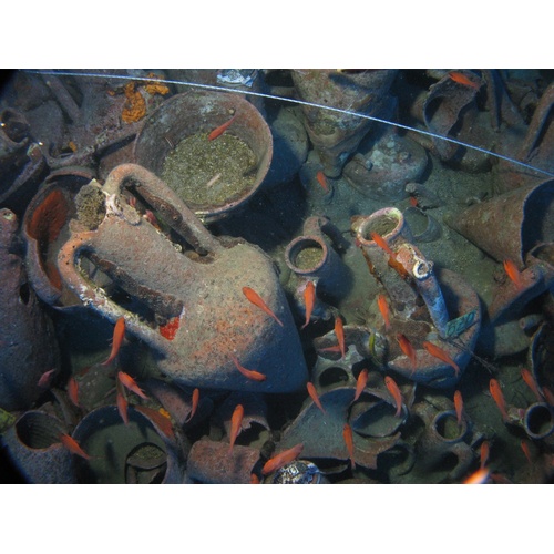
The cargo was almost homogeneous: it consisted of wine amphorae, mostly from Chios [Fig. 3]. They date to the first half of the 4th century (380-350) BC, that is to the Late Classical period.[25] The north Aegean islands, famous for their wine-production in the ancient world, almost held a monopoly on high-quality wine from the Archaic to the Hellenistic periods.[26] The wine of Chios in particular was of excellent quality and perhaps one of the most expensive ones, with a wide distribution within and beyond the Aegean.[27] Apart from Chian amphorae, six different types, also Greek, have been located in the assemblage, but in very small quantities. Ten of them come from the southeastern Aegean and are characterized by their mushroom-shaped rim.[28]
The Mazotos ship’s homogeneous cargo implies an almost direct course from the north Aegean. Its final destination cannot be determined, but the position of the wreck on the sea-route that linked the Aegean to the eastern Mediterranean leads us to believe that it sailed either eastwards, towards Kition or Salamis, or southeast, towards the Levant. Such long-distance trade ventures that presuppose complex networks and prearranged transactions are frequently mentioned in the written sources of the period.[29] Regular contacts, however, are attested mainly between the Greek cities and the kingdoms of the Black Sea; impressive quantities of Chian amphorae in particular, from Black Sea sites, can hardly be compared to those from Syro-Palestinian or Cypriot sites.[30] Based on what is known about the distribution of Greek amphorae thus far, Chian wine was known in the eastern Mediterranean but was consumed in small quantities, at least prior to the Hellenistic period.[31]
The historic context of the Mazotos shipwreck may help us to understand its importance better. During the first half of the 4th century, realignments in the international political and economic setting were successive and linked to the Persian state’s expansion policy and preservation of sovereignty, the successful and unsuccessful responses of the Greeks, and the revolts of independence by Cyprus, Egypt and the Phoenician cities.[32] In this context, the Mazotos shipwreck poses some very interesting research questions regarding trade connections between the eastern Mediterranean and the Aegean, especially during periods of political tension and war.
2.2.2. The Kyrenia shipwreck
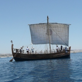
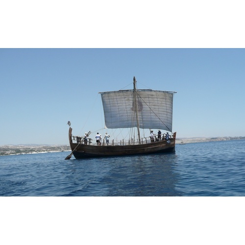
At the beginning of the 3rd century BC, during the early Hellenistic period, another ship from the Aegean sank off the north coast of Cyprus, close to Kyrenia.[33] It was transporting wine and almonds mostly from Rhodes and other Aegean islands.[34] The ship’s keel was 13.8 metres long, and hence it was a small to medium size commercial ship of that era, of similar size to the Ma’agan Mikhael shipwreck. The fact that the port side of the hull was preserved in good condition was of particular importance since it allowed the reconstruction of the ancient ship, which was fully assembled with mortise and tenon joints. It is the most complete example of Classical merchantman, olkas (ολκάς) in ancient Greek, known thus far [Fig. 4].[35]
The cargo of the Kyrenia shipwreck is one of the earliest assemblages of Rhodian amphorae in Cyprus. Rhodian wine imports continued well into the Hellenistic period and were the most prominent on the island, as far as distribution and quantities are concerned.[36] This is well attested in the archaeological record, although the sites along the north coast are less well documented due to the interruption of archaeological work after the Turkish military invasion of 1974.
Given the remarkable changes that occurred in the trade networks of the eastern Mediterranean during the Hellenistic period, the role of Rhodes as the last Aegean stopover of ships sailing towards the Levant and Egypt was significantly upgraded. Good Rhodian wine, a popular Greek commodity in the new markets, could be carried by ships of all sizes. These maritime routes passed either along the south coast of Cyprus or perhaps along the northern coast, depending on the final destination. The large quantities of Rhodian amphorae that have been located in Cyprus provide a tangible proof that many more vessels from the Aegean, such as the Kyrenia ship, had important commercial transactions with the harbour cities of the south and east coast of the island, especially during the Hellenistic period.
Conclusions
The diachronic persistence of ancient sea routes is associated with the sailing ships’ direct dependence on the prevailing winds and currents, at least until the Medieval period.[37] Trade networks created on these routes might cluster, expand or shrink, according to the politico- economic conditions of each historical period. Cyprus developed close connections with the surrounding mainland, from which it was only few sailing days away. In periods of commercial prosperity, the local and peripheral trade networks of Cyprus and the Aegean, organically linked at the coasts of Lycia, expanded; maritime ventures such as those represented by the shipwrecks examined above, are the best manifestation of these extended spheres of interaction.
These four ships presented above, may represent only moments in the long durée of Cypriot maritime history, yet they sank at typical places along the island’s seaborne trade networks. The heterogenous Archaic cargo of Kekova Adasi is indicative of cabotage along the Lycian coasts, where Cypriot and Aegean products were redistributed from the main harbours to smaller ones. The ship that sank off the coast of Kyrenia, some three centuries later, had probably also passed along the sea of Lycia on the way from Rhodes. If the ship that wrecked at Ma’agan Mikhael did come from the Aegean, it followed a different route after Lycia, and sailed southeast towards the Levant, via the south coast of Cyprus. A similar course was also taken by the Mazotos ship, coming from the northern Aegean. Thus, through these random nautical accidents, we trace sea routes that underscore the central role of Cyprus in the maritime landscape of eastern Mediterranean
1 Simmons 1999; Demesticha 2012.
2 Pryor 1988, 95; Murray 1995, 38-43; Wachsmann 1998, 295-296; Arnaud 2005, 212.
[3] Iacovou 2013; Kassianidou 2013; Knapp 2013, 397-432.
[4] Reyes 1994, 122-151.
[5] Westerberg 1983.
[6] Basch 1987, 250.
[7] Calvet 1986; Jacobsen-Winther 2002; Leidwanger 2005-2006; Levent-Zoroğlu 2013.
[8] Gunneweg, Perlman 1991.
[9] Greene, Leidwanger, Özdaş 2013, 26.
[10] Pomey, Rieth 2005, 16-19.
[11] Morton 2001, 143-228.
[12] Arnaud 2005, 110-111.
[13] Greene, Leidwanger, Özdaş 2011.
[14] Greene, Leidwanger, Özdaş 2013, 32-34.
[15] Horden, Purcell 2000, 145.
[16] Ballard et al. 2002; Stager 2003.
[17] Greene, Leidwanger, Özdaş 2013, 28-32.
[18] Linder, Kahanov 2003.
[19] Liphschitz 2004.
[20] Kahanov, Pomey 2004.
[21] Liphschitz 2004.
[22] Tartaron 2013, 185-203.
[23] Arnaud 2005, 212.
[24] Demesticha 2011.
[25] Anderson 1954, figs 19a and 9b; Grace, Savvatianou-Petropoulakou 1970, 359-363; Lawall 2002, 202-203.
[26] Salviat 1986.
[27] Boardman 1967, 252; Sarikakis, 1986, 122.
[28] Empereur, Picon 1986, 112; Lawall 2004, 451; Lawall 2005, 33.
[29] Reed 2003.
[30] Dupont 1998.
[31] Demesticha 2009.
[32] Maier 1994.
[33] Swiny, Katzev 1973.
[34] Lawall 2011, 674-679.
[35] Steffy 1994, 42-59.
[36] Barker 2013; Dobosz 2013.
[37] Gluzman 2010.
